The Romans
Tuesday 20 February 2024
The Romans in Peterborough and the Nene Valley
Boudicca's Revolt 60AD
Queen Boudicca was married to Prasutagus ruler of the Iceni of East Anglia. When the Romans conquered southern England in AD 43, they allowed Prasutagus to continue to rule. However, when Prasutagus died the Romans decided to ignore his will, which left his kingdom shared between his daughters and the Romans, and to rule the Iceni directly. They confiscated his property and are also said to have stripped and flogged Boudicca and attacked her daughters. These actions exacerbated widespread resentment at Roman rule.
In 60 AD, while the Roman governor Gaius Suetonius Paullinus was on campaign in North Wales, the Iceni led by Boudicca, rebelled and were joined by other tribes. In response the Ninth Legion based at Longthorpe Fortress and led by Quintus Petillius Cerialis marched to meet her army, but they were defeated and she went on to destroy Camulodunum (Colchester) the capital of Roman Britain.
Boudicca's warriors then destroyed London and Verulamium (St Albans) killing thousands. Suetonius marched back from Wales and finally defeated her. She is thought to have poisoned herself to avoid capture. The site of the battle, and of Boudicca's death, are unknown.
Car Dyke Creation 60AD
Car Dyke is a vast canal approximately 85 miles long stretching from the River Witham south of Lincoln to Waterbeach near Cambridge. There is a huge amount of uncertainty about when the canal was built, or its use, but it was present in the Roman period.
Theories
The canal follows the western edge of the fenland, hugging the 6m level, which was also thought to be the edge of the Iron Age coastline. The two main theories regarding the canal are that it was used for transportation, or for drainage. There is some suggestion that it was in place in the Iron Age, but there is little to support this theory. An alternative theory is that it marks a boundary line between large Roman Imperial estates to the west of the fen edge and Boudiccan tribes in the east. This idea would date the structure to as early as 60AD.
Where Can I View Car Dyke?
Car Dyke is still extant in several places in and near Peterborough. Frank Perkins Parkway follows the line of Car Dyke for several miles before it gets to Eye, where it turns sharply to the west and continues along the edge of Paston, Gunthorpe and Werrington until it reaches Peakirk. From Peakirk much of the canal is only discernible using crop marks, regaining its structure again in Lincolnshire. Much of the visible structure is scheduled, but can be walked along. Some of it exists within private property and cannot be accessed.
On the Roman Road System 101AD - 200AD
The Antonine Itinerary was a catalogue of the road network in England and Europe during the second century. It recorded the names of important towns and the distance between them, which would have been useful information to anyone travelling through the country, in particular any military troops.
Durobrivae, the Roman town at Water Newton, has its first reference in the Antonine Itinerary and was part of Route 5, a journey from London to Carlisle. It was recorded as the stop between Cambridge and Ancaster, being 35 miles from Cambridge and 30 miles from Ancaster.
Ptolemy's Geographia 101AD - 200AD
Claudius Ptolemy was born in Greece and lived in Alexandria. He was a very talented man and was credited as an astronomer, geographer, mathematician and astrologer. He created several works including a book known as Ptolemy's Geographia, which incorporated knowledge from gazetteers, astronomers and other academics to craft maps and indexes of the known world.
The original book was thought to contain maps too, but all of the existing maps are from Medieval Europe.
The map of the British Isles is a rather crude interpretation of the area, but it indicates the most important towns in Roman Britain. Roman Leicester (Ratae) and Caistor in Norfolk appear to be on the map and the town between them on the map might just be Durobrivae sitting by the River Nene. As one of the largest towns in Roman Britain, it should be on the map!
The Praetorium at Castor
Underneath St Kyneburgha's Church, Castor are the remains of one of the biggest buildings in Roman Britain. Parts of its walls still can be seen in various parts of the village. The site has been explored over several hundred years with early antiquaries confused by what the mosaic floors and several bath houses all meant. We now know that the site was probably part of a vast Imperial Estate from where much of the fenlands was governed. The building appears to have been the administrative centre of this estate and was where a procurator would have held court and possibly lived. The building on the top of the rise, where the church now stands, would have been seen for miles as a symbol of Roman power and authority.
Roman Industrial Suburbs of Normangate Field
The area to the south of Ailsworth and Castor villages is known as Normangate Field. It was the site of extensive Roman pottery and metal working workshops. The Roman road of Ermine Street runs through the area. It can be seen today as a massive bank of earth concealed underneath several hundred years of repeated road surfacing. The potteries here gave their name to the distinctive Roman pottery known at Castor Ware. Interpretation from 2018 has revealed that the Normangate Fields contained a complex and thriving community. The location of the fields put the pottery and metal workers in an excellent position. They were near the Praetorium, Durobrivae and Rive Nene for water-based transport. Also, not only were they straddling Ermine Street, but King Street too. It is possible that King Street was once much more important than Ermine Street based on the location of the workers.
The Roman Town of Durobrivae
A bridge was built across the River Nene around AD 65, after which a small settlement grew to the south west of the bridge. This prospered as a market centre for trade along the important Ermine Street, the precursor to the modern A1. The town had walls around it for protection and status, and developed major public buildings where a town council met and organised local government, which had controls over roads, cemeteries, baths, water supply and all aspects of the daily life of the town. Added to the towns market importance was its rich sources of clay and iron which were the key resources of a major pottery and metal working industry. The importance of Durobrivae lies in the fact that although the town walls covered 44 acres, the industrial suburbs extended for another 450 acres making a major settlement in Roman Britain. It remained a prosperous town until the end of Roman occupation of Britain.
Roman occupation on Cathedral Site
Archaeological evidence around and underneath the Cathedral indicates that there was a Roman building on this site, including evidence of a boundary ditch and monumental stonework. This may indicate a substantial building, possibly a temple or monumental arch, confirmed by a huge amount of Roman pottery found in an archaeological dig in 2016. If this building was a temple, it is interesting to speculate whether it was later rededicated as a church when the Romans became Christians. A carving previously thought to be Saxon is now identified as Roman, possibly depicting fates or spirits.
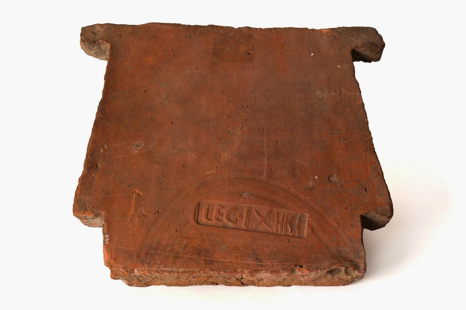
Sennianus Fired a Mortarium
A fabulous fragment of Roman pottery was discovered in Water Newton. It is a piece of a mortarium, which is kitchen ware used for grinding and pounding food. This piece is remarkable because of the painted text near the rim of the pottery.
The text was likely to have been painted by the potter who made the pot. His name was Sennianus and he lived in Durobrivae. We know this because he painted 'Sennianus Durobrivis Urit', which is Latin for 'Sennianus of Durobrivae fired this.' This is a very valuable piece of pottery because there are very few references to the name Durobrivae. This is the only British example of the name Sennianus, but a German funerary stela also bares the name. The stone object was discovered in Cologne in 1650, is mid third century, and can be seen in the link provided.
The height of the pottery making industry at Durobriave was in the late 2nd century (175-199AD). Pottery created around Durobrivae is known as Nene Valley Ware. The most common type of Nene Valley Ware is colour-coated ware, which has distinctive white decoration on a black coloured pot. However, the mortarium that Sennianus created was a light brown colour. It was designed to be used in the kitchen, so did not require elaborate decoration.
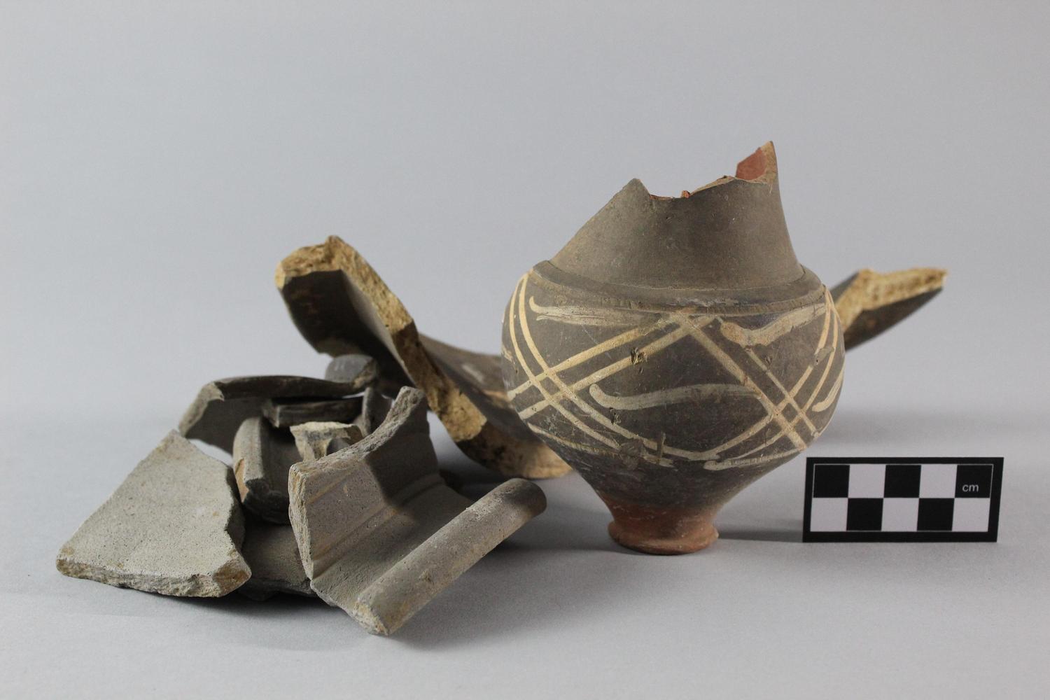
Cunoarus' Stamped Mortarium
The Roman town of Durobrivae sat on the south bank of the river Nene near Water Newton and Castor. On the northern banks of the river was a densely-packed industrial area which centred on pottery and iron production.
The area produced grey wares, colour-coated wares and kitchen wares which included mortaria. The mortaria were much thicker pieces of pottery designed for pounding and grinding. They were used to grind food, but also paints, makeup and other items. Pestles were usually made from wood and therefore do not survive with the mortaria.
One piece of Nene Valley mortarium was found with the stamp of its maker on the rim or flange. Stamped mortaria are very common and found in large numbers from locations including St Albans (Verulamium) and Vindolanda. What makes the stamped mortarium from Durobrivae important is that it refers to Durobrivae. The stamp reads 'Cunoarus Vico Duro' in Latin, which translates to 'Conoarus of the vicus of Durobrivae'. A vicus was a name used for a large village or small town in Roman Britain.
No date has been given to the mortarium, but the height of the pottery making industry at Durobraivae was in the late 2nd century (175-199AD). A stamped mortarium can often be dated but Cunoarus does not have any other surviving stamped pieces that we know of.
Roman Curses in Bretton?
A Roman well was discovered in Bretton during an archaeological dig. The well was lined with thick stone slabs leading archaeologists to believe the well was probably special to the people who used it.
There were many things found in the bottom of the well. These included shoes, nails and animal bones. They also found three pieces of tree bark, birch tree bark to be exact. The bark was neatly folded up and appeared to be placed in the well deliberately, but what was it for? When a specialist saw the folded bark she described them as looking like curse tablets. Curse tablets were often pieces of bark or lead where people wrote a nasty note in the hope of cursing someone. They were folded up and thrown into water where they believed the gods would read them and act on the curse.
Unfortunately, there are no signs of writing or scratching on the bark that would indicate they were used as curse tablets, but they had been sitting in the well for over 1600 years! They could have been folded over food as an offering to the well, or used as a container as birch bark still is today. There is, however, something exciting about discovering a potential angry curse from 1600 years though and we can only wonder at what could have been written on there and who was being cursed...
Do You Know When Bricks Were First Used in Peterborough?
The Romans are first credited with making bricks in Britain. Their bricks were usually a red colour and often black inside. They look different to modern bricks because they were made by hand and were lots of different shapes and styles. Some look like tiles and others look like long thin bricks the length of one or two feet. Plenty of Roman bricks have been discovered in the Peterborough area, many of which would have been made in the Normangate Field area south of Castor and Ailsworth. If you want to see Roman bricks in a building, a visit to the Jewry Wall in Leicester is recommended.
Roman Fenland Ranch
The Fens are known for their boggy nature and were inhospitable to many in the past. However, during the Roman period the rivers silted up and much of the area was usable land. It is therefore not surprising that archaeologists are finding increasing evidence of both occupation and habitation now that modern photography and lidar images can help us see below the seemingly flat fenland fields.
Chestnuts Farm is located between Thorney and Throckenholt and is fortunate enough to have evidence of a Roman drove running through a paddock. The Roman period is well known for the straight lines of its roads and buildings and this is no exception. The drove runs in a straight line from north west to south east across the site with two parallel ditches on each side. Associated with the drove are other fields running off it at right angles and the suggestion of at least one building. Rather than considering these to belong to a group of people it is believed that they belong to one group and the fields belong to a ranch.
Other Roman features nearby have been dated to the 2nd-3rd centuries, with the area being too wet outside of these times, which might suggest a similar date for this site. However the ground sits on a very wide roddon or silted up river, which provides both higher and more stable ground, so it could have existed outside of the dates.
The feature is on private land and not accessible by the public, but it is possible to view on satellite maps and lidar images.
Reference: Roman Drove, Enclosures and Building Platform at Chestnut Farm, Ancient Monuments, https://ancientmonuments.uk/10
Archaeological Discoveries Timeline
Mosaic Found in Milton Park 1720
In 1720 a mosaic was found in Milton Park, home to the Fitzwilliam family. It was said to have belonged to a ‘villa of some Roman distinction’, which, given the number of large villas in the vicinity is not surprising. The Milton estate abuts the village of Castor, famed for the Praetorium, one of the largest buildings in the country at the time. Several buildings with impressive mosaics were also discovered by Edmund Artis in the vicinity of Castor. including one near Helpston.
According to Historic England Milton Hall’s stables were extended in 1720 and this is likely to be when the mosaic discovery was made. However, Edmund Artis was said to have discovered a large mosaic in Castor in 1821 and had it transported to the hall, where it was placed in the dairy. Is it possible that there has been some confusion and the 1720 date was a typographic error? Or were the extended stables built on a Roman villa, now lost under the buildings
References: Milton Hall, Historic England, https://historicengland.org.uk/listing/the-list/list-entry/1000628, http://www.thearchive.org.uk/thebook/5parishes/colour_plates.pdf
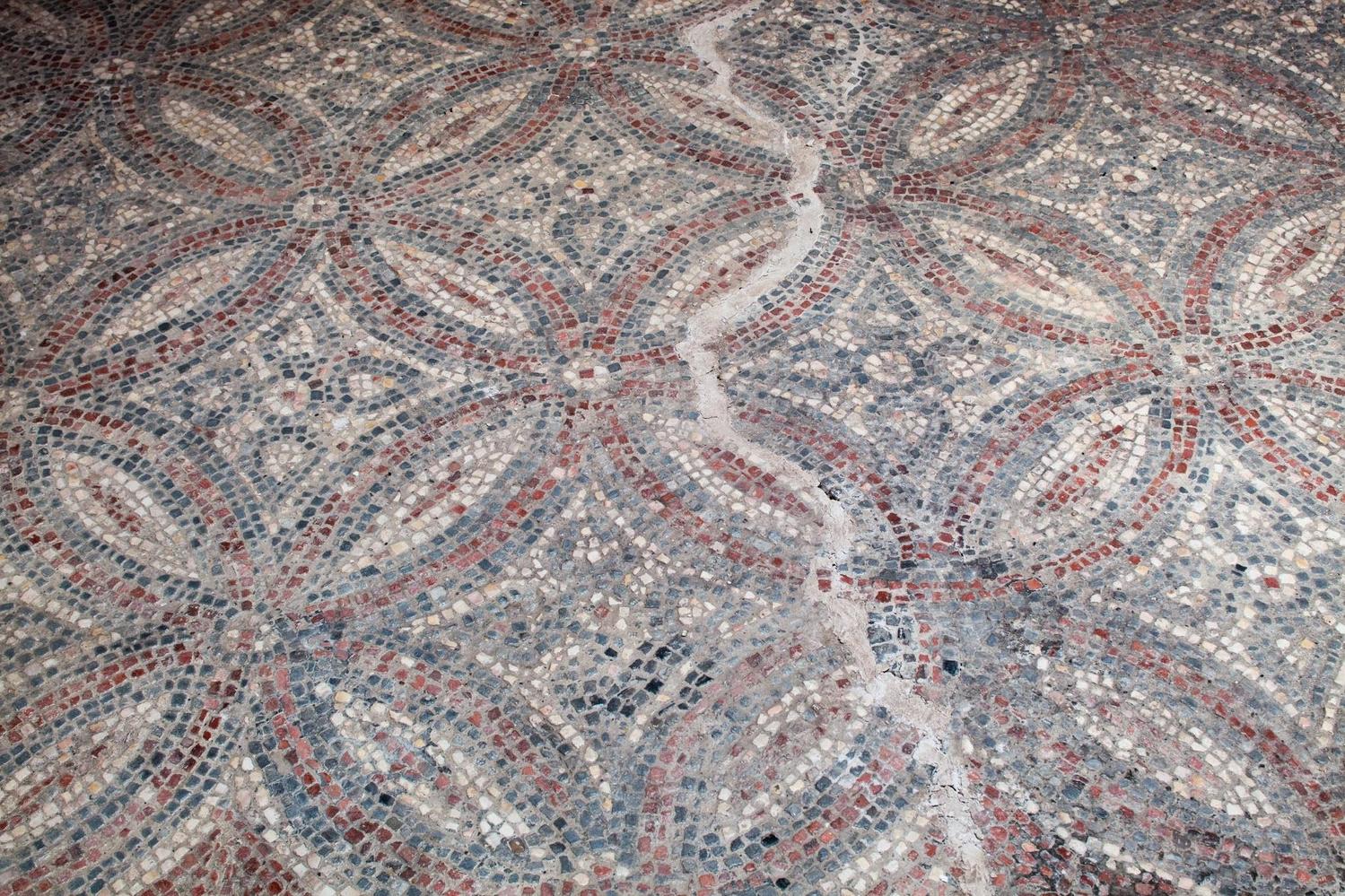
Mill Hill Villa 1822
Mill Hill is an area to the south east of Castor, near to the river Nene. It sits within a rich landscape of Roman archaeological remains due to its proximity to Durobrivae.
A Roman villa was discovered on Mill Hill which had evidence of a courtyard, mosaic flooring and hypocausts. The villa is high status and shares some similarities with other villas nearby. It appears that high status villas were built close to the river Nene and Durobrivae, but lower status villas were further away from the valley and more rural.
Edmund Artis was the local antiquarian who first uncovered the villa. He drew his interpretation of the area, which comprised several buildings with sizeable walls. He made detailed illustrations of the mosaic flooring, which contain a striking checker board pattern. Artis' plans were first published in 1823 after excavation in 1822. Later analysis has revealed the mosaic was created by a guild of local mosaicists who operated in the mid to late fourth century and crafted mosaics in Durobrivae and in what is now Lincolnshire.
Victorian Lime Kiln Finds 1879
An 1888 map of Peterborough showed the location of Roman discoveries to the west of the East Coast mainline in what is now called Lime Kiln Close. The Roman artefacts were described as ‘Roman Coins, ornaments &c’ and were discovered between 1879 and 1885, presumably due to the creation of lime kilns on the site. A supposed Roman Road ran only a few metres west of the site and A few hundred metres away further Roman finds were discovered by the now listed Perkins Engines building on Westfield Road. A 1950 map declared Roman coins and pottery were discovered there in 1920 too, suggesting further Roman activity in the area.
Reference: OS County Series: Northamptonshire, 1888-1889, 1:10,560 accessed via old-maps.co.uk
Orton Hall Farm 1960's - 1970's
Archaeological excavations in the 1960's and 1970s revealed a large first century farmstead in the vicinity of Hall Farm in Orton (near to modern day Leighton Primary). The site was first in use from around 50AD and continued to be used well into the Saxon period. The farm house had a yard with a wall around it, and there were large barns and a mill too. Agricultural activities were evident, as well as beer production and milling, suggesting some wealth was attached to the farmstead.
Roman Pottery Kilns in Stanground 1965
Local Roman enthusiasts will be familiar with the pottery kilns in Normangate Field near Castor. However, there was also a pottery industry in Stanground too.
During the 1960s there were several excavations to explore Roman features under what is now Park Farm. Archaeologists discovered four pottery kilns dating from the early to mid-third century (200-250 AD). There was also a 'pottery dump', several ditches, burials and coins too.
15 coins were found in total, which could all be dated to between 260 AD and 350 AD. This suggests that the site was abandoned by around 365. It also suggests that the site had two different uses over two different time periods. Interestingly, two of the ditches discovered on the site were dated to pre-Roman activity, possibly Iron Age. This extends the use of the site over several centuries.
Analysis of the clay on the site identified two distinct types. One clay was finer and would have been used for high-end pottery. The other was used for every-day ware and would have been chosen for more rigorous domestic use. Over 240 kilograms of pottery were identified during excavations, not all had been created at the site though. A mixture of grey ware, colour-coated ware, cream ware and shell-gritted ware were discovered. These were represented as beakers, dishes, flagons, jars and dishes on the whole. Pottery created on the site has been found at other local Roman sites including Orton Hall and Peterborough Cathedral.
Early Roman Fortress 1967
Longthorpe Roman fortress, in the location of the present day Thorpe Wood Golf Course, was built at the beginning of the Roman occupation in what appears to be a hurried way, suggesting that its purpose was to get Roman presence into the area quickly. It sat on a small ridge facing the river, and could hold half a legion, in this case, the Ninth. Despite being built in a rush, it was the only Roman fort in western Europe to have an onsite pottery and it produced excellent quality wares. The Ninth Legion was sent to quell Boudicca’s rebellion at Camulodunum (Colchester) in around 60AD and the few soldiers who did return were badly injured. With too few soldiers to sustain and defend the fort, it was redesigned to a much smaller scale.
Ailsworth Roman Villa 1968
Several villas are found very close to Durobrivae including one in Ailsworth. According to Pevsner, Ailsworth Roman Villa is 'S W of the station beside the Nene, c. 1/2 m upstream of the ford.' The station no longer exists, although the train line is still in use as the Nene Valley Railway. Searching south west of the crossing provides the correct location.
Pevsner claims that the villa had 'hypocausts, mosaic floor, and further tessellated pavement [and] seems to have been similar to that of the villa at Apethorpe (Northamptonshire). It also sounds remarkably similar to the villa a very short distance away on Mill Hill. It was only partly excavated by Edmund Artis in the Nineteenth Century, so very little is known about the villa.
Reference: Pevsner, N., Bedfordshire, Huntingdonshire and Cambridgeshire, (Yale University Press, 1968) p204
Stories From Skeletons 1972
We have a fascinating insight into Roman lives in what is now Ferry Meadows thanks to the Coney Meadow Cemetery, which was in use around 200-300AD. Archaeologists excavating at Lynch Farm Site 3 discovered that the people who were buried here had tough lives, through analysis of skeletons found at the site. These skeletons give us an understanding of death and disease in Roman Britain, through a family with arm abnormalities, children with ear infections and women with new-born babies. There were also fragments of cheap, rough pottery close to the burials and a large aisled barn nearby.
Farming at Nene Park 1972
A clue to life as a Roman in Nene Park, is the remains of a large timber barn on Roman Point, probably used for furnace and smithing work for making small tools. Also close by are a well and a shallow tank, which experts think could be for making salt from the then-tidal flow of the River Nene. These features were part of a larger farming complex, known to archaeologists as Lynch Farm, which had several barns similar to this one.
Lynch Farm Fort 1972
The area known as Lynch Farm has mainly been incorporated into Ferry Meadows. Three separate archaeological digs have looked at the features hidden under the ground under Coney Meadow. They have revealed extensive prehistoric activity which suggest a small oppidum (fortified town). Furthermore there is evidence to suggest that a small Roman fort was built there.
Lynch Farm Fort was built within the boundary of the possible oppidum and was in use at about the same time as Longthorpe Fort. Longthorpe Fort sits on higher ground to the east, whereas Lynch Farm Fort sits lower in the valley. It is also a short distance from the fort at Waternewton, which was a key crossing point over the River Nene.
The close proximity of the forts may have been a tactical response to conquer the area from local tribes. This is because the River Nene and its valley was a rich resource and important for travel purposes. It is also believed that a road crossed north to south past the fort. It forded the river close to where Ferry Bridge is nowadays, linking with another road by Longthorpe Fort.
The area is scheduled, but can be enjoyed whilst visiting Ferry Meadows.
Water Newton Treasure 1975
The Water Newton Treasure is a hoard of silver vessels and plaques which forms the earliest group of Christian liturgical silver yet found in the Roman Empire. It was discovered in a recently ploughed field at Water Newton, the site of the Roman town of Durobrivae, in February 1975. The hoard was much damaged by the plough. It consists of nine vessels, a number of silver votive plaques, and a gold disc.
Many of the objects in the hoard bear inscriptions of the monogram formed by the Greek letters chi (X) and rho (P), the first two letters of Christ's name, a symbol commonly used by early Christians. Two bowls and one plaque have longer inscriptions in Latin. One of these, on a bowl, can be translated as, 'I, Publianus, honour your sacred shrine, trusting in you, 0 Lord.' Other inscriptions give the names of three female dedicators; Amcilla, Innocentia and Viventia, who must also have belonged to the congregation.
Individual pieces in the treasure were probably made at different times and in different places, and it is impossible to establish accurately the date at which they were hidden. The treasure may have been hidden in response to specific persecution of Christians or to more general political instability.
The Roman Villa at Fane Road 2011
An Iron Age farmstead developed into a prestigious Roman villa with mosaic floors and a hypocaust. The building was improved and extended several times before it was demolished in about AD350.
The Roman villa and Iron Age farmstead were unearthed by an excavation in 2011-12 triggered by the planned development of houses on a portion of the allotment site. The discovery of this villa caused great local interest and in 2014 a community excavation was launched to find its southern wing.
The Oldest Ice Skates in Peterborough 2011
Ice skating was an integral part of the winter fenland identity until very recently. When winters were harsh, rivers, stream, dykes and ditches would all freeze over, as well as flooded fields. With thousands of acres of flat flooded land, the fens boasted many champion skaters and there are even stories of children skating to school.
Ice skates were often tied onto boots and looked very different to modern ice skates. They could be made from anything that would allow people to slide along ice, including large animal bones or narrow pieces of metal. Skates or runners could also be used to transport heavy items in the same way we attach coasters or wheels to items today.
Two skates or runners were discovered during an archaeological dig on Bretton Way, where the Eaglewood Neurological Care Centre is now sited. The skates were made from horse bones and showed signs of smoothing and scratching consistent with use. They were discovered inside a large stone-lined well and archaeologists believe that they might have been used to transport the stones that lined it, however they can't rule out personal use either. The well the skates or runners were found in is Roman, but they are presumed to be Saxon or Medieval, because no evidence of skates have been discovered in the country earlier than that date. However, it should be noted that the majority of the features found across the site are of Roman origin and they may well be Roman too. Whatever their date, they are exceedingly unusual and potentially unique.
Reference: A. Pickstone, Iron Age and Roman Remains at Bretton Way, Peterborough, Post Excavation Survey, (Oxford Archaeology East, 2011)
Roman Fort at Water Newton 2012
The Roman fort at Water Newton was part excavated in 2012 and although thought to be built as part of the Roman invasion to house troops conquering Britain, the excavation showed that it was constructed 20 years later in the aftermath of the Boudican revolt of AD 60. The fort only lasted for a matter of a few months as the Roman armies re-organised the road system in this part of the east Midlands and built a new stone bridge over the river Nene. Once built this bridge spawned a small, new settlement which developed into the Roman town of Durobrivae. The fort was initially discovered in 1930 and was confirmed in 1938 by the use of aerial photography. It covers an area over 5 acres and sits about 1,000 feet from the river.